
TALETE- Tutela del pAtrimonio cuLturale da evEnti esTremi di prEcipitazione: il quartiere di Santa Croce a Firenze
In questa pagina
Coordinator: prof. Enrica Caporali
Project financed by Regione Toscana - Fondo Sociale Europeo (FSE) per l’alta formazione e la ricerca in ambito culturale. Co-financed by Biblioteca Nazionale Centrale di Firenze, Opera di Santa Croce, Fondazione Cassa di Risparmio di Firenze, DICEA/UNIFI.
Start: March 2020
End: April 2022
Since the creation of the concept of “History”, humankind has strived to protect and preserve the cultural heritage handed down from one generation to another. Worldwide, historical cities are a great collector of cultural and artistic heritage which represents not only an inestimable value but also a fundamental source of income needed for supporting heritage preservation itself. The uncontrolled expansion of built-up areas, the unsuitableness of drainage systems and the increasing occurrence of climate extreme events are threatening museums, ancient palaces, religious buildings, libraries, etc.
In this framework and looking at the upsetting climate forecasts, the project named TALETE- Tutela del pAtrimonio cuLturale da evEnti esTremi di prEcipitazione: il quartiere di Santa Croce a Firenze (Protecting the cultural heritage from pluvial floods: the Santa Croce district in Florence) aims to protect the cultural heritage guarded in the most vulnerable areas of Santa Croce district from damages caused by pluvial floods. In particular, researchers are deeply investigating the compound of the National Central Library of Florence, which counted almost 1.2 million volumes flooded during the catastrophic inundation of the Arno River of 1966.
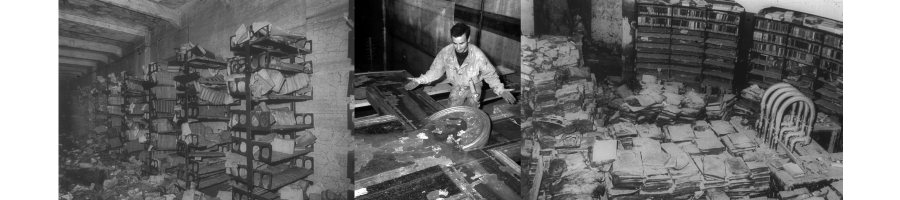 Cultural heritage flooded during the inondation of the Arno river of 1966
(Images dx e sx are photos by Peter Waters, Courtesy of National Central Library of Florence; central photo is by Ivo Bazzechi, Ivo Bazzechi Cimabue Flood, marked as public domain, more details on Wikimedia Commons)
Since there are no updated technical drawings of the studied drainage system, the former activities focused on the recovery of every useful information from historical, statal, digital archives followed by systematic field surveys to identify and measure manholes and pipes. Advanced technics, such as high-resolution Ground-Penetrating Radar (GPR), have been used to detect underground and disregarded structures. The geometrical specifications represent the basic data for the hydraulic model. The hydraulic modelling of the drainage network exploits the most advanced numerical techniques, coupling the 1D simulation of the flow through the pipes with the 2D simulation of the surface runoff generated by rainstorms and by the sewer overflow. The modelling process will allow to identify the critical points and drive the planning of strategies aimed at defending the cultural heritage.

Related project: FLORENCE - FLOod risk and water REsources management with Nature based solutions on City Environment
Dissemination
- Protecting Florence’s past from the future, https://blogs.autodesk.com/innovyze, Eric Suesz - February 20, 2023
-
Climate.Culture.Peace - Case Studies, Conference 24 - 28 January 2022
Tamagnone P., Caporali E., Sidoti A., Facing Climate Extremes to Protect the Heritage:The Santa Croce District in Florence - ResearcGate project - TALETE - Tutela del pAtrimonio cuLturale da evEnti esTremi di prEcipitazione: il quartiere di Santa Croce a Firenze
Ultimo aggiornamento
07.03.2023